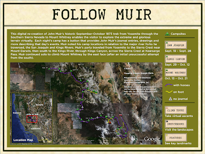
 Here is a part of an installation I worked on at the Oakland Museum of California. On August 5, 2011, we opened a new show called "A Walk in the Wild: Continuing John Muir's Journey". One of the interactives that I worked on will allow visitors to virtually join Muir during his epic trek during the fall of 1873 to the top of Mount Whitney. It was called "Follow Muir" and it runs on top of Google Earth. The user interface for that presentation was being custom-built by Lawrence Dolton at ViewPoint Geography, but the data is going to be made available for everyone to download and use. The data was specifically built to run on both the personal computer and the tablet (iPad) versions of Google Earth. It'll work on an iPhone, but it may not be easy to use.
The tour consists of a series of "campsite" placemarks connected by purple (with horses) and yellow (on foot) paths. Most campsites include a pop-up balloon with Muir's journal notes and drawings, along with other additional info. There are also a series of "Fly-bys" which allow you to visually "follow Muir" on one of four peak ascents, as well as a number of "Sketchbook" photo-views which places Muir's sketches into the landscape - use the transparency slide here to help you see what Muir saw.
Here's how you can try it out ...
To download Google Earth for your PC or Mac, click here.
To download the data file for Google Earth on your PC or Mac, click here.
The iPad version does not include the "Fly-bys" or the "Sketchbooks", as these are not supported in the app - but you get everything else, sized for consumption on your tablet.
To add this data set to your iPad, do the following:
1. Get and login to a Google AccountCurious about Muir's journal? You can check out the whole thing here.
2. Find the map data at this link
3. Click on "Save to my places".
4. Install Google Earth on your iPad
5. Click the "Layers" button in GE on your iPad
6. Login to "My Maps Account"
7. Select "John Muir Climbs Mt. Whitney"


